Differential Absorption Lidar (DIAL) Measurements of Pollutants and Greenhouse Gases from Industrial Emissions
In the third part of our series on the optical measuring methods is presented a mobile emissions monitoring system based on Differential Absorption Lidar (DIAL), a sophisticated laser-based remote sensing technique developed and operated by the National Physical Laboratory (NPL) in the UK. The DIAL technique is the basis of a method that has recently been standardised in Europe within EN 17628 (2022) and is applicable for the measurement of diffuse and fugitive emissions from industrial sources.
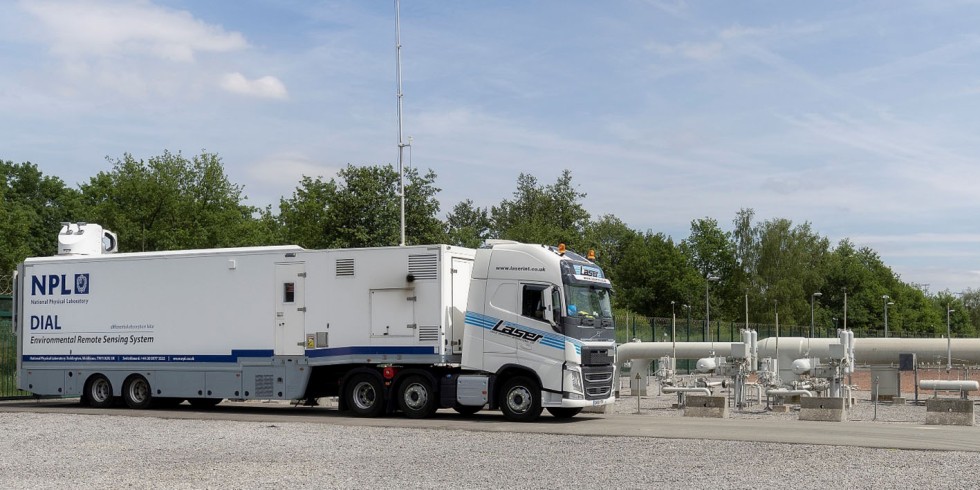
Figure 1 Picture of NPL’s DIAL system. Photo: Fluxys Belgium – David Samyn
DIAL is a is an optical remote sensing method capable of making spatially resolved measurements of concentration of a target gas (in this case methane) along the path of a laser beam transmitted into the atmosphere. It combines the use of light detection and ranging (lidar) to measure backscattered light from the atmosphere and the targeted species dependent differential absorption of two known, pre-selected, wavelengths of light. One of these (λon) is strongly absorbed by the species of interest while the second pulse (λoff) is at a wavelength that has a much weaker absorption. The difference in the absorption of the two wavelengths allows the concentration of the gas to be calculated along the optical path. Spatial resolution is obtained by pulsing the laser beam allowing both the location and concentration of emission sources to be determined. The ability to scan the optical measurement beam through a vertical plane in the atmosphere enables the gas concentrations to be mapped within the atmosphere and emission rates to be determined when the concentration data are combined with wind data.
DIAL systems have been used for over 30 years
The mobile DIAL systems developed at NPL for the remote measurements of pollutants and greenhouse gases have been used world-wide for over 30 years at different industrial facilities such as refineries, Liquid Natural Gas terminals, tank farms, biogas, wastewaters and landfills utilising both the infrared (IR) and ultraviolet (UV) regions for different species such as volatile organic compound (VOCs), methane, ethane, SO2, NOx, HCl and benzene. The current DIAL system is housed in a mobile laboratory and is self-contained, running off an internal generator, see Figure 1 (see above).
Measurement performance
In order to perform measurements, the NPL DIAL has to ‘stand-off’ by a minimum measurement distance of 50 m (measurements cannot be undertaken in the first 50 m from the trailer) so the DIAL does not have to be located in the emission plume. In the IR the strength of the returning DIAL radiation depends on atmospheric conditions as the transmitted eye-safe radiation is returned by scattering from aerosol/dust particles in the atmosphere. Therefore, the maximum scan range of the IR DIAL system depends on the atmospheric conditions and varies from day to day and can also change throughout the day.
Wind data is collected using a fixed meteorological mast which is typically located in an open area. This mast supports four wind sensor packages at 11,9 m, 9,0 m, 6,2 m and 3,4 m elevation from the ground. A 2,3 m high portable mast is also deployed near the DIAL truck or along the measurement line-of-sight. The DIAL truck is also equipped with an inbuilt telescopic 10,5 m high meteorological mast. The meteorological data are recorded using battery powered loggers, with a two second sampling rate, which is then processed to provide vector averaged wind data for the periods of each DIAL scan. The four wind speeds measured at different heights on the fixed mast are used to construct an unperturbed logarithmic vertical wind speed profile. The local wind speed measured by the portable and DIAL sensors are used to check if there were significant differences with the fixed mast unperturbed wind speed at the same elevation, for example due to the presence of obstacles such as buildings. The calculated wind field is then combined with the measured gas concentration profile providing a mass emission rate value in kg/h. An exemplar contour plot from a DIAL scan is shown in Figure 2.

Figure 2 Example concentration profile measured by DIAL in a vertical plane.
Foto: NPL
BAT conclusion includes DIAL as a technique to monitor diffuse VOC emissions
The European Union as part of its Industrial Emissions Directive 2010/75/EU has published the Best Available Techniques (BAT) reference document for the refining of mineral oil and gas. The BAT conclusion includes DIAL as a technique to monitor diffuse VOC emissions from industrial sites. In response to this the European Committee for Standardisation (CEN) produced a new Standard, EN 17628 (2022), for the use of systems such as DIAL to monitor the fugitive emissions of VOCs. The Standard defines the performance requirements of the measurement system, the application of the methodology and the quality control. (Figure 3)

Figure 3. Results from the Standard validation field campaign comparing the NPL DIAL VOCs emission rate measurements to blind controlled release rates.
Foto: NPL
Measurement standards
A DIAL measurement is defined in the Standard as the average of a set of, typically four, repeated scans. The standard uncertainty of each DIAL measurement is estimated based on the standard deviation of the individual emission rate measurements from which each mean emission rate value has been determined. As such it encapsulates variability occurring during the measurements which will include the measurement itself (random DIAL measurement uncertainty), variability in the source emissions, and variability in the wind direction and speed used since for each scan a different wind profile is calculated from the wind data collected on site. In the Standard validation (see Figure 3) and demonstration field studies as well as in previous DIAL validation studies, the standard uncertainty of a set of at least four DIAL scans has been showed to be representative of the measurement uncertainty. These studies also confirmed the dominant DIAL uncertainty sources have a random behaviour with the systematic biases in the DIAL measured emission estimates being less than 4 %. When summing the emissions from different parts of the site which have been measured separately, for example when calculating total site emissions, the reported standard uncertainty is the sum in quadrature of the standard uncertainties of each contributing measurement. Such total uncertainty is relatively low when compared to a single DIAL measurement. This is expected for methods where the dominant uncertainty sources have a random behaviour since, by increasing the number of measurements (and scans) the uncertainty can be expected to decrease accordingly.
The wind quality controls define a minimum wind speed requirement of between 0,5 m·s–1 and 1,0 m·s–1 and a minimum angle of 20° to 30° between the scanning plane and the wind direction for a scan to be considered valid. This is not a definitive rule and the validity of a scan is assessed on an individual basis by checking the wind stability (persistence) over the measurement period. The persistence is a measure of the variability of the wind and ranges from zero to one. The more stable the wind is the closer the persistence value is to one. For the purposes of DIAL measurements, the persistence can help to assess the validity of a measurement scan. A persistence of less than 0,9 during a measurement scan indicates relatively high variability in the wind direction and warrants a more detailed assessment to determine whether the measurement is valid. All three of these parameters (wind direction/scanning plane angle, wind speed and persistence) need to be considered to assess if each individual scan is valid or not.
Similar levels of emissions from different sources
NPL have used the DIAL in a large number of research and commercial measurement campaigns throughout the world. For example, measurements of methane emissions at a number of facilities at various stages in the natural gas distribution and storage infrastructure. Measurements at one natural gas storage site located and quantified emissions from the storage holders themselves and provided separate quantification of the emissions from the pressure reduction and re-pressurisation stages that connected the site to the main natural gas distribution network. The results showed similar levels of emissions from these different sources. Another set of measurements was made at a different storage site where the gas was held in liquefied form in insulated cryogenic tanks. In this case, minimal emissions were detected from the storage tanks themselves. The site emissions were dominated by those from the gas processing area where the gas was liquefied prior to storage and then vaporised and re-pressurised for injection back into the gas distribution network. Some additional point emissions were also measured that were related to site maintenance activities. It has been a common feature of many DIAL measurement exercises that short term deviation from normal operating conditions often results in additional emissions, and that on large and complex sites this can add significantly to the overall emissions.
Measurements of the emissions of methane from onshore Liquid National Gas (LNG)
Recently NPL have used the DIAL system to carry out a series of measurements of the emissions of methane from onshore Liquid National Gas (LNG) plants across different regions of the world (see Figure 4). This study combined DIAL measurements with walkover surveys to identify individual component leaks, to understand emissions from sites and from sub-areas of the sites, termed functional elements, which group distinct areas of the site by function (e.g. storage, gas liquefaction, processing, power generation). Combined with knowledge of the process conditions within the site, emission factors relating emissions to activity data such as total LNG throughput were derived. These enable comparison of the emissions from different sites, at site and at functional element level. This study is one the first to provide emissions data from the LNG supply chain, and was carried out as part of the Climate can Clean Air Coalition (CCAC), UNEP, Environmental Defence Fund, and the Oil and Gas Climate Initiative (OGCI) Global Methane Studies Programme. (Figure 4)

Figure 4. Picture of the DIAL in operation at a LNG facility.
Foto: privat
The combination of wide area coverage and range-resolved measurements means that the DIAL method is well suited to carrying out detailed studies of emissions from area sources. Since the DIAL method directly maps the atmospheric distribution of the emissions, the emitted rate can be calculated without assumptions about source distribution and plume behaviour or reference to dispersion models. This removes one major source of uncertainty from emission results and means that DIAL can be used to measure emissions when topography or meteorological conditions would lead to unreliable dispersion modelling.
Measurements on sites with difficult access
Another benefit of the DIAL method in this type of application is that the single ended, remote nature of the technique means that measurements can be made of emissions from sites or areas of a site where access is difficult or hazardous, as long as the DIAL system can be located within its measurement range of around 500 m.
A good example of area methane sources is the emission of landfill gas from waste management sites. Landfill gas results from the (mainly anaerobic) biodegradation of the organic fraction of landfilled waste, and typically contains between 40 % and 60 % methane (the remaining gas is mainly carbon dioxide, with trace levels of various non-methane hydrocarbon compounds). The distribution of emissions across any given site is highly heterogeneous because it varies with the site activity at the time of measurement, the content of the waste being landfilled and the route to surface of the emitted methane from capped areas which can involve diffusion through the capping layers, escape through faults in any gas control system or migration through geological features.
A study compared five different methods for measuring fugitive methane emissions from a landfill site. In addition to the IR DIAL, the other methods included radial plume mapping using open-path laser absorption spectroscopy, in-situ sensing combined with dispersion modelling with and without associated tracer gas measurements, and a helicopter-borne near-infrared topographic reflection system.
In two days of measurement the DIAL system was able to quantify the methane emissions from different areas of the landfill and identify and map the localised emission sources around the site. The measurements showed that, as expected, the active cell had the highest emission levels than the closed cells. The localised emissions from the gas engine were measured specifically, and showed a low rate of around 1 kg/h. Given the size of the site, the emission rate corresponded to approximately 15 kg/h/hectare for the active area on this site.
Results and Conclusions
The results of this study confirmed the ability of IR DIAL to provide methane emission rate measurements and 2D visualisations of the emission distributions without requiring specific site access or configuration, unlike the in-situ or open-path methods. The conclusion was that, although the DIAL system was bigger and more complex than the other methods, it had greater potential to be deployed at any landfill site and provide an accurate area-by-area analysis of the site emissions.
Another landfill study investigated the methane emissions from two adjacent landfill sites in the USA. The emissions from each area of the site were mapped and quantified over the 6 days measurement campaign which also included half a day measuring a controlled methane release. As with the previous study, the active tipping areas of the sites were the source of the majority of the emissions, although in this case it was noted that the emission levels from the active areas on both sites were significantly higher during periods of active tipping. The area-weighted emission rates from the active areas were approximately 40 kg/h/ha and 55 kg/h/ha during the tipping periods, and approximately 15 kg/h/ha and 14 kg/h/ha during the quiet periods. Again, these measurements have shown the capability of IR DIAL to quantify the methane emissions from complex large area sources in a short space of time.
In a current study NPL has deployed the DIAL system, alongside walkover surveys and long-term measurements using the NPL Fugitive Emission Detection System (FEDS) to determine methane emissions from several Anaerobic Digester (AD) plants. This is part of a study Methane Emissions from Anaerobic Digesters (MEAD) being carried out by NPL for the UK Government department for Business, Energy and Industrial Strategy (BEIS). The study demonstrates the different roles carried out by different monitoring approaches, and the DIAL measurements have identified a number of potential methane emission points on AD plants.
These examples demonstrate the established role that DIAL has in determining the mass emission of pollutants and GHGs from industrial facilities. The recent standardisation of methods such as DIAL provide regulatory authorities and industry with the tools to monitor and report site and sub site level emissions and to identify and quantify emission sources. NPL have characterised the DIAL system performance and have recently published papers on the uncertainty in the DIAL measurements [1,2]. NPL continue to develop and improve the DIAL technique, including current work within the EURAMET research project DECARB and within NPL’s internal research programme to extend the capability of NPL’s DIAL system to be able to quantify CO2 emissions.
Literatur
- Gardiner, T.; Helmore, J.; Innocenti, F.; Robinson, R. : Field Validation of Remote Sensing Methane Emission Measurements. Remote Sensing 2017, 9 (9), 956. https://doi.org/10.3390/rs9090956;
- Innocenti, F.; Gardiner, T.; Robinson, R.: Uncertainty Assessment of Differential Absorption Lidar Measurements of Industrial Emissions Concentrations. Remote Sensing 2022, 14 (17), 4291. https://doi.org/10.3390/rs14174291.
Fabrizio Innocenti, Rod Robinson,
National Physical Laboratory (NPL), Hampton Road, Teddington (Middlesex), UK, TW11 0LW.